


States – All India Anti Crime Bureau
HISTORY OF JAMMU AND KASHMIR-

Jammu and Kashmir
| Jammu and Kashmir جموں و کشمیر |
|||
|---|---|---|---|
|
|||
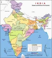
| Location of Jammu and Kashmir in India | |||
| Map of Jammu and Kashmir | |||
| Coordinates (Srinagar): 33.45°N 76.24°ECoordinates: 33.45°N 76.24°E | |||
| Country | |||
| Region | North India | ||
| Admission to Union | 26 October 1947 | ||
| Capital | |||
| Largest city | Srinagar | ||
| Districts | 22 | ||
| Government[*] | |||
| • Governor | Narinder Nath Vohra | ||
| • Chief Minister | Mufti Mohammad Sayeed(PDP) | ||
| • Deputy Chief Minister | Nirmal Kumar Singh (BJP) | ||
| • Legislature | Bicameral (87 + 36 seats) | ||
| • Parliamentary constituency | Rajya Sabha 4 Lok Sabha 6 |
||
| Area | |||
| • Total | 222,236 km2(85,806 sq mi) | ||
| Area rank | 5th | ||
| Including Azad Kashmir, Gilgit-Baltistan and Aksai Chin | |||
| Elevation | 327 m (1,073 ft) | ||
| Population (2011) | |||
| • Total | 12,548,926 | ||
| • Rank | 19th | ||
| • Density | 56/km2 (150/sq mi) | ||
| Time zone | IST (UTC+05:30) | ||
| ISO 3166 code | IN-JK | ||
| HDI | |||
| HDI rank | 17th (2005) | ||
| Literacy | 66.7% (21st) | ||
| Official language(s) | Urdu[1] | ||
| Other spoken | Kashmiri, Dogri, Hindi,Punjabi, Ladakhi[1] | ||
| Website | jk |
||


Jammu and Kashmir is a state in northern India. It is located mostly in the Himalayan mountains, and shares a border with the states of Himachal Pradesh and Punjab to the south. Jammu and Kashmir has an international border with China in the north and east, and the Line of Control separates it from the Pakistani-controlled territories of Azad Kashmir andGilgit–Baltistan in the west and northwest respectively. The state has special autonomy under Article 370 of the Indian constitution.[2][3]
A part of the erstwhile Princely State of Kashmir and Jammu, the region is the subject of a territorial conflict among China, India and Pakistan. The western districts of the former princely state known as Azad Kashmir and the northern territories known asGilgit-Baltistan have been under Pakistani control since 1947. The Aksai Chin region in the east, bordering Tibet, has been under Chinese control since 1962.[note 1]
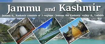
Jammu and Kashmir consists of three regions: Jammu, the Kashmir Valley and Ladakh. Srinagar is the summer capital, andJammu is the winter capital. The Kashmir valley is famous for its beautiful mountainous landscape, and Jammu’s numerous shrines attract tens of thousands of Hindu pilgrims every year. Ladakh, also known as “Little Tibet“, is renowned for its remote mountain beauty and Buddhist culture.
The state, Jammu and Kashmir, is the only state in India with a Muslim-majority population[10] (while Jammu has a Hindu-majority).
History of Mumbai
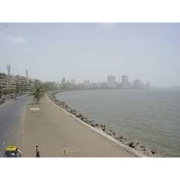

The history of Mumbai recounts the growth of a collection of seven islands on the west coast of India, becoming the commercial capital of the nation, and one of the most populous cities in the world. Although human habitation existed since the Stone Age, the Kolis, a marathi fishing community,[1] were the earliest known settlers of the islands. The Maurya Empire gained control of the islands during the 3rd century BCE, and transformed it into a centre of Hindu and Buddhist culture and religion. Later, between the 2nd century BCE and 9th century CE, the islands came under the control of successive indigenous dynasties: Satavahanas, Abhiras, Vakatakas, Kalachuris, Konkan Mauryas, Chalukyas andRashtrakutas, before being ruled by the Silharas from 810 to 1260.
King Bhimdev established his kingdom in the region in the late 13th century, and brought many settlers to the islands. The Muslim rulers of Gujaratcaptured the islands in 1348, and they were later governed by the Gujarat Sultanate from 1391 to 1534. The Treaty of Bassein between the Portuguese viceroy Nuno da Cunha and Bahadur Shah of the Gujarat Sultanate placed the islands into Portuguese possession in 1534.
The islands suffered incursions from Mughals towards the end of the 17th century. During the mid-18th century, the city emerged as an important trading town, with maritime trade contacts with Mecca and Basra. Economic and educational development characterised the city during the 19th century with the first-ever Indian railway line beginning operations between Mumbai and neighbouring Thane in 1853. The city became a strong base for the Indian independence movement during the early 20th century and was the epicentre of the Rowlatt Satyagraha of 1919 and Royal Indian Navy Mutiny of 1946.[2] After India’s independence in 1947, the territory of Mumbai Presidency retained by India was restructured intoMumbai State. The area of Mumbai State increased, after several erstwhile princely states that joined the Indian union were integrated into Mumbai State.
In 1960, following protests from the Samyukta Maharashtra movement, the city was incorporated into the dominion of the newly createdMaharashtra State from Mumbai State. The city’s secular fabric was torn apart in the communal riots of 1992–93, while the bombings of 1993caused extensive loss of life and property. The city was renamed Mumbai in 6 March 1996.
Geologists believe that coast of western India came into being around 100 to 80 mya after it broke away from Madagascar. Soon after its detachment, the peninsular region of the Indian plate drifted over the Réunion hotspot, a volcanic hotspot in the Earth’s lithosphere near the island of Réunion. An eruption here some 66 mya is thought to have laid down the Deccan Traps, a vast bed of basaltlava that covers parts of central India. This volcanic activity resulted in the formation of basaltic outcrops, such as the Gilbert Hill, that are seen at various locations in the city. Further tectonic activity in the region led to the formation of hilly islands separated by a shallow sea.[3]Pleistocene sediments found near Kandivaliin northern Mumbai by British archaeologist Todd in 1939 indicate habitation since the Stone Age.[4] The present day city was built on what was originally an archipelago of seven islands of Bombay Island, Parel, Mazagaon, Mahim, Colaba, Worli, and Old Woman’s Island (also known asLittle Colaba).[5] The islands were coalesced into a single landmass by the Hornby Vellard engineering project in 1784. By 1000 BCE, the region was heavily involved in seaborne commerce with Egypt and Persia.[6] The Koli fishing community had long inhabited the islands.[7] They wereDravidian in origin and included a large number of scattered tribes along the Vindhya Plateau, Gujarat, and Konkan. In Mumbai, there were three or four of these tribes. Their religious practices could be summed up as animism.[8]